

West Contra Costa Transportation Commission
West County Action Plan for Routes of Regional Significance
The sub-regional plan: which roads carry traffic between West County and the rest of the Bay Area, the standards set for them, and the projects and programmes meant to meet those standards.
Plan · Final draft · 2014 · 39 figures · about 25 min to read
The sub-regional plan: which roads carry traffic between West County and the rest of the Bay Area, the standards set for them, and the projects and programmes meant to meet those standards.
Current — In force. This is the version to rely on. The last published draft; nothing later has been issued.



Draft
West County Action Plan for
Routes of Regional Significance
Prepared for: and January 2014 WC13-3009.02
Appendix A: Index to Actions by Route Appendix B: MTSO Values

Introduction
In November 2004, Contra Costa voters renewed the original Measure C Transportation Improvement and Growth Management Program, a ½-percent sales tax to fund transportation projects and programs, with a new ballot measure called Measure J. Measure J, which started in April 2009, will generate approximately $2 billion (in 2008 dollars) over a 25-year period.
Measure J continues Contra Costa’s innovative Growth Management Program (GMP). To receive its share of local street maintenance and improvement funds and to become eligible for Transportation for Livable Communities (TLC) funds, a local jurisdiction must be found to be in compliance with the GMP, which requires each jurisdiction to
Adopt a Growth Management Element
Adopt a local and regional Development Mitigation Program
Participate In an Ongoing Cooperative, Multi- Jurisdictional Planning Process
Address Housing Options
Develop a Five-Year Capital Improvement Program
Adopt a Transportation Systems Management (TSM) Ordinance or Resolution
Adopt a Voter-Approved Urban Limit Line Among these elements, preparing action plans for routes of regional significance is included under the requirement to “Participate in an Ongoing Cooperative, Multi-Jurisdictional Planning Process”. The specific requirements of this element as defined in Measure J are as follows:
Each jurisdiction shall participate in an ongoing process with other jurisdictions and agencies, the Regional Transportation Planning Committees and the Authority to create a balanced, safe and efficient transportation system and to manage the impacts of
Original PDF, page 6
WCCTAC | West County Action Plan El Cerrito | Hercules | Pinole | Richmond | San Pablo Bayview-Montalvin | Crockett | East Richmond Heights El Sobrante | Hasford Heights | Kensington |North Richmond Port Costa | Rodeo | Rollingwood | Tara Hills growth. Jurisdictions shall work with the Regional Transportation Planning Committees to:
- Identify Routes of Regional Significance, and establish
Multimodal Transportation Service Objectives for those routes and actions for achieving those objectives.
- Apply the Authority’s travel demand model and technical procedures to the analysis of General Plan Amendments (GPAs) and developments exceeding specified thresholds for their effect on the regional transportation system, including on Action Plan objectives.
- Create a development mitigation program.
- Help develop other plans, programs and studies to address other transportation and growth management issues.
In consultation with the Regional Transportation Planning Committees, each jurisdiction shall use the travel demand model to evaluate changes to local General Plans and the impacts of major development projects for their effects on the local and regional transportation system and the ability to achieve the Multimodal Transportation Service Objectives established in the Action Plans.
Jurisdictions shall also participate in the Authority’s ongoing countywide comprehensive transportation planning process. As part of this process, the Authority shall support countywide and sub-regional planning efforts, including the Action Plans for Routes of Regional Significance, and shall maintain a travel demand model. Jurisdictions shall help maintain the Authority’s travel demand modeling system by providing information on proposed improvements to the transportation system and planned and approved development within the jurisdiction.1 The Contra Costa Transportation Authority (“the Authority”) is responsible for evaluating whether each jurisdiction is fully complying with the GMP. With Measure J, the jurisdiction’s eligibility to receive Transportation for Livable Community funding may also be withheld for non-compliance with the GMP. 2 The purpose of the Action Plans is for each Regional Transportation Planning Committee (RTPC) to work cooperatively to establish overall goals, set performance measures (called Multi-modal Transportation Service Objectives, or MTSOs) for designated Routes of Regional 1 Measure J: Contra Costa’s Transportation Sales Tax Expenditure Plan, Contra Costa Transportation Authority, July 21, 2004, pp. 24 & 25.
2 The Contra Costa TLC Program funds transportation enhancement projects in urban, suburban and rural communities to support a balanced transportation system, create affordable housing, and make Contra Costa’s communities more pedestrian, bicycle, and transit friendly.


Original PDF, page 7
Introduction
Significance, and outline a set of projects, programs, measures, and actions that will support achievement of the MTSOs. Action Plans are required to be prepared by the RTPC for each subarea of Contra Costa County (West, Central, East, Lamorinda, and the Tri-Valley). The Authority is responsible for funding this effort, and for coordinating and knitting together the Action Plans from each RTPC into the Countywide Comprehensive Transportation Plan (CTP).
The West County Action Plan contains the following components: Routes of Regional Significance (Chapter 2) identifies the Routes of Regional Significance within West County.
Current Commuting Patterns and Overall Growth Trends (Chapter 3) looks at long-range land use changes and anticipated traffic growth. Action Plan Goals and Objectives (Chapter 4) describes the overall goals of the plan, and identifies the MTSOs that are applied to each Regional Route.
Proposed Regional Actions (Chapter 5) identifies specific actions, programs and measures, and assigns responsibility for their implementation.
Procedures for Notification, Review, and Monitoring (Chapter 6) includes project notification procedures and the process for general plan review.
The following terms, which are used repeatedly in this document, are defined below: Policies. The policies of an Action Plan help guide its overall direction.
Decisions regarding investments, program development, and development approvals are based on these policies. Goals. A goal is a statement that describes in general terms a condition or quality of service desired that is in line with the policies. For example, a common goal from past Action Plans was to “provide and encourage the use of alternatives
Original PDF, page 8
WCCTAC | West County Action Plan El Cerrito | Hercules | Pinole | Richmond | San Pablo Bayview-Montalvin | Crockett | East Richmond Heights El Sobrante | Hasford Heights | Kensington |North Richmond Port Costa | Rodeo | Rollingwood | Tara Hills to the single-occupant auto.” This goal would be in line with a policy that calls for “an efficient transportation system.” Multi-Modal Transportation Service Objectives. MTSOs are specific, quantifiable objectives that describe a desired level of performance for a component of the transportation system.
Actions. Actions are the specific programs, projects, measures, or steps that are recommended for implementation to meet the MTSOs set forth in the Action Plan. The responsibility of carrying out the actions falls to the individual local jurisdiction, or to the Regional Committee as a whole. Actions may involve implementing specific projects at the local level, or they may call for the RTPC to support major projects that have a regional impact. Implementation of adopted actions is a required condition of compliance with the Measure J GMP.
Routes of Regional Significance. Routes of Regional Significance are roadways that connect two or more subareas of Contra Costa, cross County boundaries, carry significant through traffic, and/or provide access to a regional highway or transit facility. The Authority may designate a Regional Route that meets one or more of these criteria.


Original PDF, page 9
Routes of Regional Significance
The Action Plan designates a system of Routes of Regional Significance, as defined in this chapter. One of the key elements of the Action Plan is the designation of the Routes of Regional Significance. The RTPCs have the authority to propose designation of Routes of Regional Significance in their regions.
In considering what routes to designate, the Measure J GMP guidelines recommend four questions that are outlined below. These are not absolute rules (i.e., a transportation facility that answers yes to one or more of these questions is not required to be designated as a Route of Regional Significance), but are meant to guide the RTPC in identifying the routes that are very important transportation corridors in their region.
- Does the road connect two or more “regions” of the County?
- Does the road cross County boundaries?
- Does the road carry a significant amount of through-traffic?
- Does the road provide access to a regional highway or transit facility (e.g. a BART station or freeway interchange)?
The RTPC may propose, and the Authority may designate, a Regional Route that meets one or more of the above criteria. Alternatively, some routes that meet one or more of the criteria can remain undesignated, provided that a consensus not to designate such routes is reached among affected jurisdictions. Furthermore, routes that enter or leave the RTPC require joint discussions among the affected regional committees to determine if consensus can be reached regarding designation.
In this Action Plan, the WCCTAC Board has chosen to remove the Route of Regional Significance designation from four previously-designated routes, namely: Cutting Boulevard, El Portal Drive, Macdonald Avenue, and Willow Avenue. In its discretion, the Board determined that these routes primarily or exclusively served travel within a single jurisdiction, and that these routes would not receive enough benefit from the inter- jurisdictional planning process required by this Action Plan to justify their inclusion in the Regional Route network.

Original PDF, page 10
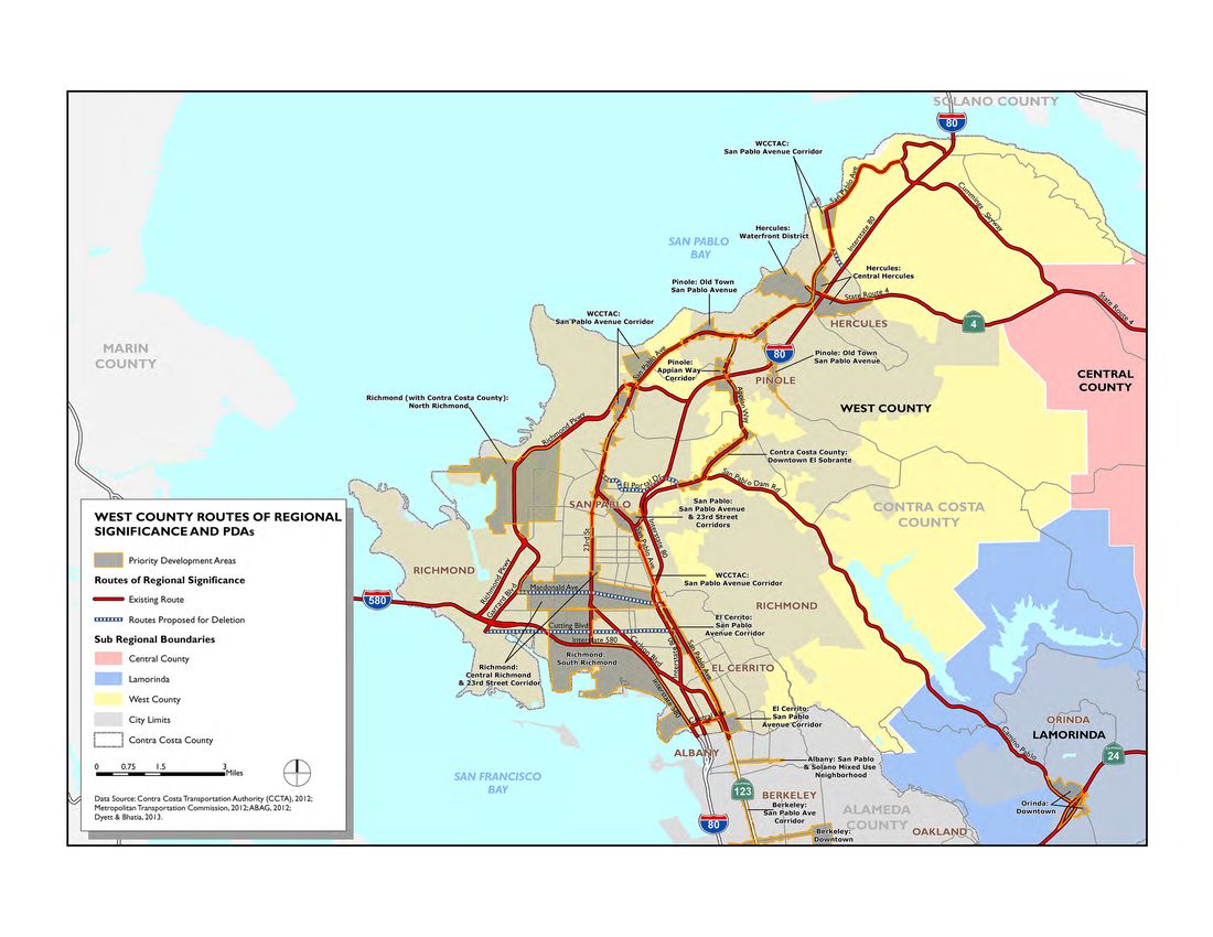
WCCTAC | West County Action Plan El Cerrito | Hercules | Pinole | Richmond | San Pablo Bayview-Montalvin | Crockett | East Richmond Heights El Sobrante | Hasford Heights | Kensington |North Richmond Port Costa | Rodeo | Rollingwood | Tara Hills The Routes of Regional Significance are shown in Figure 2-1. A description of each route is as follows:
- Appian Way. From San Pablo Avenue to San Pablo Dam Road.
- Carlson Boulevard. From 23rd Street to San Pablo Avenue.
- Central Avenue. From San Pablo Avenue to I-580.
- Cummings Skyway. From San Pablo Avenue to SR 4.
- Interstate 80. From the Alameda County line to the Solano County line. I-80 is the primary inter-regional commute corridor through West
County, and has major regional significance to the Bay Area.
- Interstate 580. From I-80 to the Marin County line. I-580 carries inter- regional traffic between the East Bay and the North Bay.
- Richmond Parkway. From I-80 to I-580 (including Garrard Boulevard portion). Richmond Parkway is an important connector for traffic traveling between I-80 and I-580.
- San Pablo Avenue. From the Alameda County line to I-80/Pomona
Street in Crockett. San Pablo Avenue is the most important corridor for inter-city travel in West County: it is the primary transit spine of the region, it travels through all of the West County cities (in many cases, functioning as “Main Street”), and it is the primary reliever route to I-80 during periods of severe freeway congestion.
- San Pablo Dam Road. From San Pablo Avenue to the boundary with the Lamorinda region. San Pablo Dam Road is an important intra-County route, connecting travelers from I-80 in West County to SR 24 in Orinda, and it also serves as the primary commercial corridor for El Sobrante.
- State Route 4. From I-80 to Cummings Skyway. SR 4 carries intra-
County traffic between West County, Central County and East County.
- 23rd Street. From San Pablo Avenue to I-580.
Original PDF, page 11
Figure 2-1 West County Routes of Regional Significance
WCCTAC | West County Action Plan El Cerrito | Hercules | Pinole | Richmond | San Pablo Bayview-Montalvin | Crockett | East Richmond Heights El Sobrante | Hasford Heights | Kensington |North Richmond Port Costa | Rodeo | Rollingwood | Tara Hills This page left intentionally blank

Original PDF, page 13
Current Growth Trends and Travel Patterns
Forecasts of future population and employment growth in West County, as well as projections of future travel demand on major West County transportation facilities, are drawn from the most recent available regional travel model maintained by the Authority. The current Authority travel model contains land use projections consistent with those produced by the Association of Bay Area Governments (ABAG) as part of their Projections 2011 dataset, and also contains assumptions about transportation system improvements that are consistent with the financially-constrained Regional Transportation Plan.
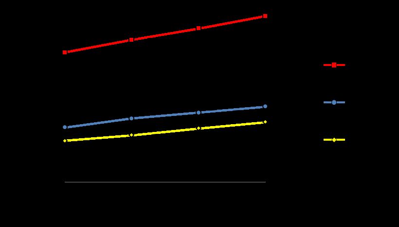
Countywide forecasts for population, employed residents, and jobs are shown in Figure 3-1. Population and job growth are expected to follow fairly similar patterns, with jobs growing at a faster rate (an average annual rate of 1.3 percent) than population (at an average annual rate of 0.8 percent).
Figure 3-1 Contra Costa County Demographic Forecasts
Original PDF, page 14
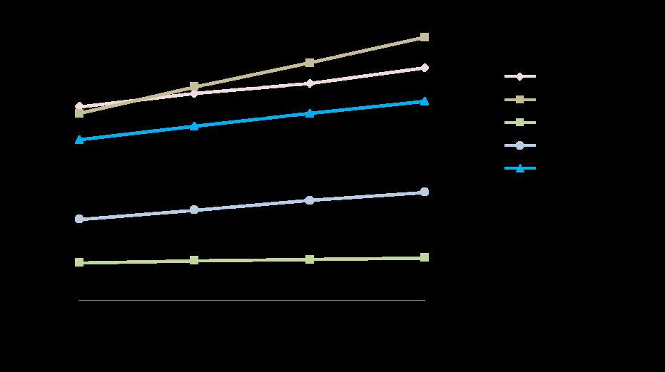
WCCTAC | West County Action Plan El Cerrito | Hercules | Pinole | Richmond | San Pablo Bayview-Montalvin | Crockett | East Richmond Heights El Sobrante | Hasford Heights | Kensington |North Richmond Port Costa | Rodeo | Rollingwood | Tara Hills Subregional forecasts for population are shown in Figure 3-2. West County is represented by the blue line. The West County population is projected to grow at a fairly modest rate (24 percent between 2010 and 2040); by 2040, West County is anticipated to be home to about 325,000 people, a lower population than Central or East County, but a much larger population than the Lamorinda area or the Contra Costa portion of the Tri-Valley. It is projected that about 24,000 new dwelling units would be added in West County in order to house the additional population.
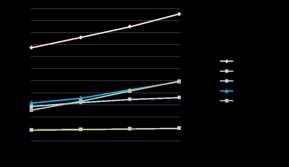
Figure 3-2 Subregional Population Growth Subregional forecasts for jobs are shown in Figure 3-3. Again, West County is represented by the blue line. Countywide, jobs are expected to grow faster than population, and West County is projected to experience significant job growth of 56 percent between 2010 and 2040, second only to East County in the rate of new jobs added. While West County will add a substantial number of jobs, Central County will continue to have the highest number of jobs of any of the subregions.
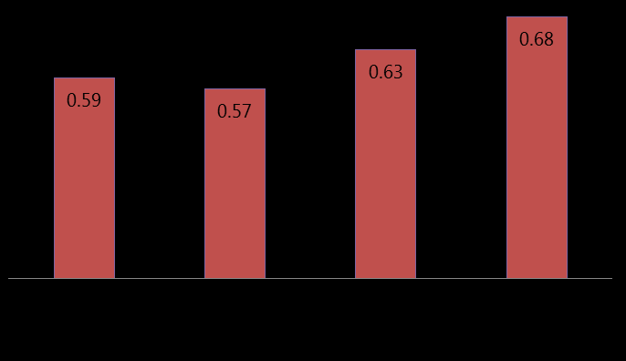
Figure 3-3 Subregional Job Growth Figure 3-4 presents the ratio of jobs-to-employed residents for West County between 2010 and 2040. A ratio of 1.0 means that the number of jobs in that subregion equals the number of employed residents; this is a measure of the balance between housing and jobs, which affects transportation topics such as commuting patterns and travel time. The

Original PDF, page 15
Current Growth Trends and Travel Patterns
ratio of jobs-to-employed-residents in West County is expected to increase, from 0.59 in 2010 to 0.68 in 2040, indicating that the balance between housing and jobs is expected to improve. However, at a ratio of 0.68, that still means that many West County residents who are employed will be commuting to jobs outside of the subregion.
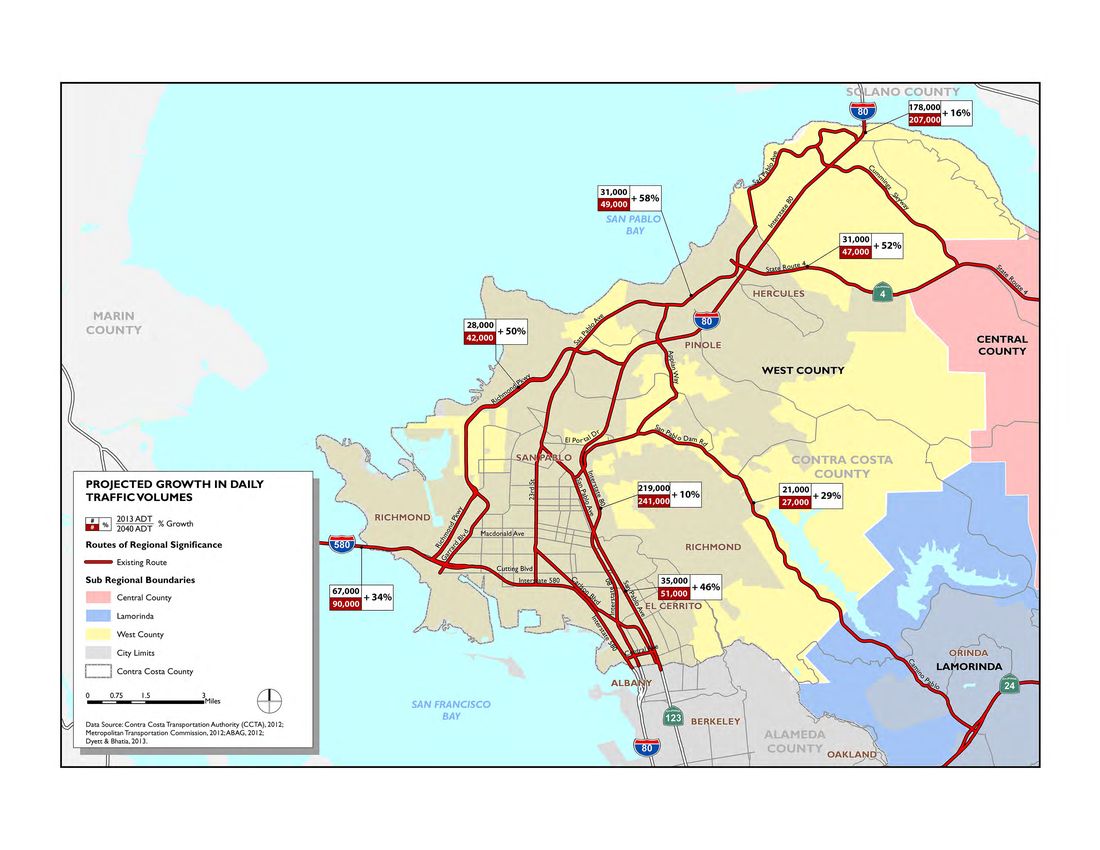
Figure 3-4 West County Jobs per Employed Resident The regional travel demand model maintained by the Authority was applied to generate estimates of the future traffic volumes expected on major roadways throughout the County. Figure 3-5 presents a map showing the projected growth in daily traffic volumes on several major facilities in West County. As is shown in this map, traffic volumes throughout West County are anticipated to increase substantially by the year 2040, as the local population continues to grow. (It should be noted that the model results shown here are intended to give an idea of the order-of-magnitude changes in traffic volumes anticipated across the region; much more detailed and refined studies would be undertaken for any specific project.)
Original PDF, page 16
Figure 3-5 Average Daily Traffic on Major Routes in West County

Action Plan Goals and Objectives
This Action Plan contains nine goals for West County. Increasing levels of congestion on major highways and arterials in West County requires continual investment in transit services that can help to address the effects of traffic growth. Enhanced local transit service helps to reduce congestion on arterials and provides critical access to existing regional transit services such as BART and Amtrak. Bus connections to major BART stations such as Richmond and El Cerrito del Norte will continue to be important areas for improvement. BART services and facilities should also be expanded as needed to serve future demand.
The existing high-capacity transit in West County is heavily utilized, but directly serves only some of the local residents and workplaces. Extending high-capacity transit to reach more of the area would increase the number of regional travel options for West County and beyond, thus spreading the travel demand over multiple modes.
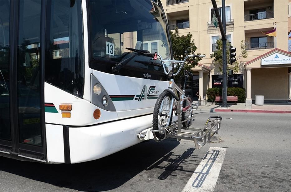
Walking and biking provide the dual benefit of environmentally friendly travel that also achieves public health goals for higher levels of physical activity. Combined with transit, walking and biking can replace longer auto trips for additional congestion and environmental benefits. West County is committed to increasing the number of trips taken via active transportation modes.
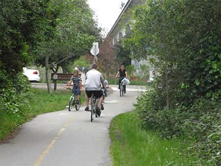
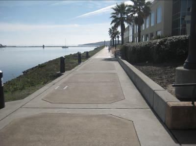
Regional trails support the use of active transportation for both recreation and commute purposes. Regional trails can also attract visitors by serving as a destination, potentially stimulating economic activity along the trail, and can help to alleviate congestion during weekends and
Original PDF, page 18
WCCTAC | West County Action Plan El Cerrito | Hercules | Pinole | Richmond | San Pablo Bayview-Montalvin | Crockett | East Richmond Heights El Sobrante | Hasford Heights | Kensington |North Richmond Port Costa | Rodeo | Rollingwood | Tara Hills other non-commute periods. West County supports efforts to complete planned trail segments and to increase connectivity to existing trails.
West County jurisdictions have adopted Complete Streets policies into their General Plans, codifying the importance of accommodating multiple modes on local streets. West County supports this effort and encourages its expansion.
Constraints on highway and roadway capacity require management of vehicle demand for those facilities. Transportation demand management (TDM) programs include a variety of strategies for increasing travel choices, including the emerging use of social media applications; these strategies are often more efficient and environmentally friendly than travel by single-occupant vehicle. Coupled with providing more travel choices, TDM programs also include an education component, thus increasing the likelihood of success. TDM strategies should be included in a package of options for decreasing the number of single-occupant auto trips.
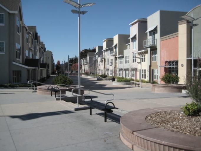
West County goals include attracting more employment to invigorate commercial centers and provide more economic opportunities for local residents, and targeting growth around high-capacity transit hubs to encourage development within Priority Development Areas (PDAs) for more efficient use of local and regional transportation resources.
Highways and major arterials in West County will continue to serve as key connections to major economic centers of the Bay Area. Improving connectivity to these facilities will ensure efficient goods movement and discourage heavy truck traffic through residential communities.
Operational improvements will smooth and balance traffic flow over all time periods, making optimal use of the existing investments in West County facilities.
West County jurisdictions and transit operators should seek adequate funds and systems to properly maintain the multimodal transportation system, recognizing that adequate maintenance is an important aspect of increasing the design life of capital investments and improving public safety.
J. Support and improve quality of life in communities impacted by rail transport.


Original PDF, page 19
Action Plan Goals and Objectives
West County hosts several freight rail lines, and many West County neighborhoods experience adverse effects of rail transport, such as noise, air pollution, and safety at track crossings. West County is committed to addressing and reducing these impacts in order to improve the quality of life for all residents.
The CCTA’s Implementation Guide gives the RTPCs significant flexibility in choosing MTSOs for their Action Plans. As long as the objective is quantifiable, and includes a timeframe for achievement of the objective, it can be proposed for inclusion in the Action Plan. Unless otherwise specified, the MTSOs proposed here are to be achieved either on an on- going basis or concurrent with completion of major projects within the specified corridor.
Selection of the MTSOs outlined below was based in part on whether the objective could be easily measured through observation and forecasted through use of the Countywide Model. The MTSOs generally remain the same as were used in the 2009 West County Action Plan; new in this plan is the definition of special zones around major transit hubs, which are subject to different performance measures than the typical MTSOs (see the section below on “Route-Specific Multi-Modal Transportation Service Objectives” for more details).
Through the adoption of Measure J, the analysis requirements of MTSOs have become more formalized. These measures will be subject to analysis for impacts of various proposed development and transportation projects, in accordance with Measure J.
Original PDF, page 20
| Descriptions of MTSOs | ||||||||||||||
|---|---|---|---|---|---|---|---|---|---|---|---|---|---|---|
| MTSO | ||||||||||||||
| Definition | Example | Sources of Information | Application | |||||||||||
| Measure | ||||||||||||||
| A measure of delay experienced by motorists on a roadway segment during a peak hour in a single direction. The Delay Index is calculated by measuring the time it takes to travel a segment of road during congested conditions, and comparing it to the time it takes to travel the same segment during uncongested, free-flow conditions. | It takes 40 minutes to drive from Point A to Point B during rush hour. The same drive takes 20 minutes during uncongested conditions at midday. Delay Index = 40 / 20 = 2.0 | Travel speeds on freeways to be monitored through Caltrans Performance Measurement System (PeMS) data, or through travel time runs conducted during congested periods. | All freeways and expressways in West County. | |||||||||||
| Delay Index | ||||||||||||||
| Signalized | A measure of traffic conditions at a signalized intersection. | Based on the number of seconds | Intersection turning movement | Arterial routes | ||||||||||
| Intersection | LOS is expressed in ratings from “A” through “F”, with “A” | of delay experienced by drivers | counts are collected every two | (listed on next | ||||||||||
| LOS | meaning that all traffic clears the intersection on every cycle | passing through the intersection. | years by CCTA as part of the | page). | ||||||||||
| and “F” meaning that drivers must wait through multiple | This metric should be calculated | MTSO monitoring program. | ||||||||||||
| cycles to clear the intersection. | using the methods specified in | |||||||||||||
| CCTA Technical Procedures. | ||||||||||||||
| A measure of the efficient utilization of the HOV lane. | Measured by counting the number of vehicles using the HOV lanes at the highest HOV volume section. | HOV volumes to be determined based on HOV lane utilization report published by Caltrans. | Freeways with HOV lanes. | |||||||||||
| HOV Lane | ||||||||||||||
| Usage |
WCCTAC | West County Action Plan El Cerrito | Hercules | Pinole | Richmond | San Pablo Bayview-Montalvin | Crockett | East Richmond Heights El Sobrante | Hasford Heights | Kensington |North Richmond Port Costa | Rodeo | Rollingwood | Tara Hills Three MTSOs are proposed to be applied in this West County Action Plan Update; the MTSOs are defined and described in the table below.


Original PDF, page 21
Action Plan Goals and Objectives
Peak hour LOS at signalized intersections along arterial Routes of Regional Significance should be at the level defined below, and calculated based on the method of analysis presented in the Authority’s Technical Procedures. Any physical improvement identified as being necessary to achieve this standard shall be evaluated for its effects on all intersection users, including pedestrians, cyclists, and transit users.
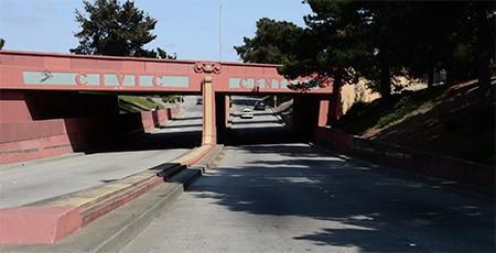
For the purposes of this Action Plan, the “PBT zones” are defined as those locations within a ½-mile radius of the following major transit hubs:
- El Cerrito Plaza BART Station
- El Cerrito del Norte BART Station
- Richmond BART Station
Travelers in urban and suburban areas have come to accept peak hour congestion, especially along freeways. West County desires to keep point-to-point travel time at a tolerable maximum and ensure that HOV lanes are well-utilized. West County also recognizes that freeway congestion, particularly along I-80, is increasingly occurring during traditionally “off-peak” times, such as during weekend days; in the evaluation of specific projects, local agencies are encouraged to consider applying these freeway MTSOs to whatever time period would be most affected by added project traffic.
The following MTSOs are defined by this Action Plan:
23rd Street: LOS D
Appian Way: LOS D
Carlson Blvd: LOS D
Central Avenue: LOS D
Cummings Skyway: LOS D
Richmond Parkway: LOS D
San Pablo Avenue: LOS E
San Pablo Dam Road: LOS E Furthermore, within specific Pedestrian-Bicycle-Transit (PBT) zones, the MTSO specified in this document will not be applied; instead, the performance standards defined within the relevant jurisdiction’s General Plan and/or a Specific Plan covering that area will govern. PBT zones shall be within a Priority Development Area, and are typically areas where transit and active transportation modes are given priority over passenger vehicles.


Original PDF, page 22
WCCTAC | West County Action Plan El Cerrito | Hercules | Pinole | Richmond | San Pablo Bayview-Montalvin | Crockett | East Richmond Heights El Sobrante | Hasford Heights | Kensington |North Richmond Port Costa | Rodeo | Rollingwood | Tara Hills CCTA is responsible for regular monitoring of the MTSOs for all the subregions, as well as for the forecasting of future MTSO values.
Appendix B contains the results of that monitoring and forecasting process for West County. The following MTSOs apply to the following facilities within West County:
I-580: Delay Index of 2.5 or less
SR 4: Delay Index of 2.0 or less
I-80: o Delay Index of 3.0 or less o HOV lane usage increased by 10% over 2013 levels

Original PDF, page 23
Proposed Regional Actions
The following table presents all of the actions proposed for this West County Action Plan. Each action is cross-referenced to the Route(s) of Regional Significance to which it applies (see the key to the Routes at the bottom of each page), as well as to the applicable Action Plan Goal(s).
The agencies responsible for taking each action are also identified; reference to “Local Jurisdictions” is intended to indicate all of the cities as well as Contra Costa County. Note that Appendix A contains a table that cross-references the Routes of Regional Significance with the proposed actions that apply to each route.
Original PDF, page 24
| ACTIONS FOR WEST COUNTY ROUTES OF REGIONAL SIGNIFICANCE | ||||||||||||||
|---|---|---|---|---|---|---|---|---|---|---|---|---|---|---|
| Applicable | Affected | |||||||||||||
| Action # | Action | Responsible Agency | ||||||||||||
| Goals | Routes | |||||||||||||
| 1 | Work with local transit providers and regional funding agencies to identify funding for and provide bus-oriented improvements along local routes, and to improve headways and expand bus service along important corridors in West County. | WCCTAC, Local jurisdictions, Transit providers | A, I | 1, 2, 3, 7, 8, 9, 11 | ||||||||||
| 2 | Implement transit-oriented development in the designated Pedestrian- | Local jurisdictions, | A | 8, 11 | ||||||||||
| Bicycle-Transit (PBT) zones using design principles that support local bus | transit providers | |||||||||||||
| services and pedestrian/bicycle access. | ||||||||||||||
| 3 | Encourage development of plans, programs and projects that support transit-oriented development within all Priority Development Areas. | Local jurisdictions, BART | G | All | ||||||||||
| 4 | Encourage development of new or expanded park-n-ride lots along freeway | WCCTAC, Caltrans, | A, I | 5, 6, 10 | ||||||||||
| corridors and at major activity centers. | Local jurisdictions, | |||||||||||||
| Transit providers | ||||||||||||||
| 5 | Partner with the Water Emergency Transportation Authority and MTC to plan and fund ferry service in West County. | WCCTAC, Cities of Richmond and Hercules | A | |||||||||||
| 6 | Participate in studies regarding passenger rail improvements in West | WCCTAC, Local | A, B, J | |||||||||||
| County, such as expansion of service on the Capital Corridor or San Joaquin | jurisdictions, Capitol | |||||||||||||
| Corridor. | Corridor JPA, San | |||||||||||||
| Joaquin JPA, BART | ||||||||||||||
| 7 | Complete the West Contra Costa Transportation Investment Study, including evaluation of transit opportunities, roadway improvements, and other projects. | WCCTAC, Local jurisdictions, Transit providers, MTC | A, B | All |
WCCTAC | West County Action Plan El Cerrito | Hercules | Pinole | Richmond | San Pablo Bayview-Montalvin | Crockett | East Richmond Heights El Sobrante | Hasford Heights | Kensington |North Richmond Port Costa | Rodeo | Rollingwood | Tara Hills
| ACTIONS FOR WEST COUNTY ROUTES OF REGIONAL SIGNIFICANCE | ||||||||||||||
|---|---|---|---|---|---|---|---|---|---|---|---|---|---|---|
| Applicable | Affected | |||||||||||||
| Action # | Action | Responsible Agency | ||||||||||||
| Goals | Routes | |||||||||||||
| 8 | Support projects and programs that improve the passenger experience, | WCCTAC, BART, | A | |||||||||||
| upgrade systems and expand the capacity of BART stations in West County. | Cities of El Cerrito | |||||||||||||
| and Richmond | ||||||||||||||
| 9 | Continue to update and implement local and regional bicycle and pedestrian plans, and support the preparation of bicycle and pedestrian plans in those communities where they do not currently exist. | WCCTAC, Local jurisdictions, CCTA | C | All | ||||||||||
| 10 | Support the WCCTAC TDM program in promoting commute methods and | WCCTAC, Local | F | All | ||||||||||
| modes that reduce single-occupant vehicle travel at peak times. | jurisdictions, 511 | |||||||||||||
| Contra Costa | ||||||||||||||
| 11 | Participate in the countywide Safe Routes to School needs assessment, and use the results of that effort to identify and seek funding for bicycle and pedestrian improvements in West County school areas. | WCCTAC, Local jurisdictions, Transit providers, CCTA | C | 1, 2, 3, 7, 8, 9, 11 | ||||||||||
| 12 | Support and participate in the efforts of Contra Costa Health Services in | WCCTAC, Local | C | 1, 2, 3, 7, 8, | ||||||||||
| providing Safe Routes to School education and encouragement programs in | jurisdictions | 9, 11 | ||||||||||||
| area schools. | ||||||||||||||
| 13 | Consider bicycle and pedestrian needs in all neighborhood and roadway planning and design efforts, particularly within Priority Development Areas. | Local jurisdictions, BART | C | All | ||||||||||
| 14 | Require new development projects to provide bike racks, lockers and other | Local jurisdictions, | C | All | ||||||||||
| secure bike parking options at appropriate locations, and seek funding to | WCCTAC | |||||||||||||
| provide bike parking at key activity centers throughout West County. | ||||||||||||||
| 15 | Support and fund programs, such as the Street Smarts Program, to increase the level of public education about bicycle safety and to reduce injuries due to pedestrian or bicycle collisions. | WCCTAC, Local jurisdictions | C |
Proposed Regional Actions
| ACTIONS FOR WEST COUNTY ROUTES OF REGIONAL SIGNIFICANCE | ||||||||||||||
|---|---|---|---|---|---|---|---|---|---|---|---|---|---|---|
| Applicable | Affected | |||||||||||||
| Action # | Action | Responsible Agency | ||||||||||||
| Goals | Routes | |||||||||||||
| 16 | Participate in planning studies for the Bay Trail extension along I-580, from | WCCTAC, City of | C, D | 6 | ||||||||||
| Castro Street to the Richmond-San Rafael Bridge. | Richmond | |||||||||||||
| 17 | Improve pedestrian and bicycle access through freeway interchange areas. | Local jurisdictions, Caltrans | C | 1, 2, 3, 5, 6, 8, 9, 11 | ||||||||||
| 18 | Conduct a bicycle route feasibility study along Richmond Parkway, and work | City of Richmond, | C, D | 7 | ||||||||||
| to improve the Bay Trail crossing at Wildcat Creek and close other trail gaps | Contra Costa County | |||||||||||||
| along the Parkway. | ||||||||||||||
| 19 | Plan and implement enhanced railroad crossings to reduce noise and quality-of-life impacts throughout West County; enhancements may involve implementing quiet zones, grade separations, train-traffic signal preemption systems, or other measures. | WCCTAC, Local jurisdictions, CCTA | H, J | 2, 3, 7, 8, 11 | ||||||||||
| 20 | Complete the reconstruction of the I-80/San Pablo Dam Road interchange. | City of San Pablo, | E, H | 5, 9 | ||||||||||
| CCTA, Caltrans | ||||||||||||||
| 21 | Support implementation, operations and maintenance of the I-80 Integrated Corridor Mobility project. | WCCTAC, Local jurisdictions, Caltrans | H | 1, 3, 4, 5, 7, 8, 9, 10 | ||||||||||
| 22 | Enhance State Route 4 to a full freeway between I-80 and Cummings | WCCTAC, CCTA, | H | 4, 10 | ||||||||||
| Skyway, including adding a connection between westbound I-80 and | Caltrans, City of | |||||||||||||
| eastbound SR 4. | Hercules | |||||||||||||
| 23 | Implement recommendations of the State Route 4 Integrated Corridor Analysis. | WCCTAC, CCTA | H | 10 |
WCCTAC | West County Action Plan El Cerrito | Hercules | Pinole | Richmond | San Pablo Bayview-Montalvin | Crockett | East Richmond Heights El Sobrante | Hasford Heights | Kensington |North Richmond Port Costa | Rodeo | Rollingwood | Tara Hills
Original PDF, page 27
| ACTIONS FOR WEST COUNTY ROUTES OF REGIONAL SIGNIFICANCE | ||||||||||||||
|---|---|---|---|---|---|---|---|---|---|---|---|---|---|---|
| Applicable | Affected | |||||||||||||
| Action # | Action | Responsible Agency | ||||||||||||
| Goals | Routes | |||||||||||||
| 24 | Explore options to extend the truck climbing lane on Cummings Skyway, | Contra Costa County | C, H | 4 | ||||||||||
| and to implement a Class II bike lane on Cummings Skyway between San | ||||||||||||||
| Pablo Avenue and Franklin Canyon Road. | ||||||||||||||
| 25 | Work with WCCTAC, local jurisdictions and CCTA to seek funding to implement recommendations of the North Richmond Truck Route Study (or other mutually agreed upon implementation measures), to improve connectivity to designated truck routes, discourage non-local heavy truck traffic on local streets, and improve public health and safety in West County communities. | Contra Costa County, Cities of Richmond and San Pablo, CCTA, WCCTAC | H | 6, 7 | ||||||||||
| 26 | Complete the improvements associated with the I-80/Central Avenue | Cities of El Cerrito | H | 3, 5 | ||||||||||
| interchange. | and Richmond | |||||||||||||
| 27 | Close gaps in the regional trail and bicycle route systems, and develop local bike route links to the Bay Trail and Richmond and Ohlone Greenways to facilitate longer-distance bicycle travel through West County and to neighboring regions. | WCCTAC, Local jurisdictions, CCTA | C, D | 3, 8 | ||||||||||
| 28 | Maintain pavement management systems and schedules, and continue to | Local jurisdictions | I | 1, 2, 3, 4, 7, | ||||||||||
| seek additional funding for local roadway maintenance. | 8, 9, 11 | |||||||||||||
| 29 | Complete a West County goods movement study, focused on ensuring efficient movement of goods while reducing impacts (environmental, health, quality-of-life) on West County residents. | WCCTAC, Local jurisdictions, Caltrans, CCTA, MTC | H, I, J | 4, 5, 6, 7, 8, 9, 10 | ||||||||||
| 30 | Comply with the CCTA Growth Management Program through monitoring | WCCTAC, Local | G | |||||||||||
| of new development proposals and General Plan amendments, and allowing | jurisdictions | |||||||||||||
| for collaboration and comment from other jurisdictions. |
Proposed Regional Actions
| ACTIONS FOR WEST COUNTY ROUTES OF REGIONAL SIGNIFICANCE | ||||||||||||||
|---|---|---|---|---|---|---|---|---|---|---|---|---|---|---|
| Applicable | Affected | |||||||||||||
| Action # | Action | Responsible Agency | ||||||||||||
| Goals | Routes | |||||||||||||
| 31 | Explore ways to increase revenue to maintain roads, transit facilities, trails, and all associated infrastructure. | WCCTAC, CCTA, Local jurisdictions, Transit providers | I | All | ||||||||||
| 32 | Investigate and support opportunities for using new technologies to reduce | WCCTAC, Local | F | All | ||||||||||
| single-occupant vehicle travel and to use existing system capacity more | jurisdictions, CCTA, | |||||||||||||
| efficiently; examples may include real-time ridesharing programs, online | Transit providers | |||||||||||||
| traveler information systems, smart highways, connected vehicles, and other | ||||||||||||||
| technologies. | ||||||||||||||
| 33 | Support and implement the West County Subregional Transportation Mitigation Program, which generates funds to support specific capital improvements throughout West County. | WCCTAC, Local jurisdictions | A, E, G | All | ||||||||||
| 34 | Improve the reliability and efficiency of bus service along San Pablo Avenue. | Local jurisdictions, | A | 8 | ||||||||||
| Transit providers | ||||||||||||||
| 35 | Implement the recommendations of the Complete Streets plans that affect San Pablo Avenue. | Cities of El Cerrito, Richmond and San Pablo | A, C, E | 1, 3, 7, 8, 9 | ||||||||||
| 36 | Implement the San Pablo Avenue Complete Streets/Bay Trail project | Contra Costa County | A, C, E | 8 | ||||||||||
| between Rodeo and Crockett. | ||||||||||||||
| 37 | Implement the recommendations of the Appian Way Alternatives Analysis and Complete Streets Study. | Contra Costa County, City of Pinole | A, C, E | 1, 8 |
WCCTAC | West County Action Plan El Cerrito | Hercules | Pinole | Richmond | San Pablo Bayview-Montalvin | Crockett | East Richmond Heights El Sobrante | Hasford Heights | Kensington |North Richmond Port Costa | Rodeo | Rollingwood | Tara Hills
| ACTIONS FOR WEST COUNTY ROUTES OF REGIONAL SIGNIFICANCE | ||||||||||||||
|---|---|---|---|---|---|---|---|---|---|---|---|---|---|---|
| Applicable | Affected | |||||||||||||
| Action # | Action | Responsible Agency | ||||||||||||
| Goals | Routes | |||||||||||||
| 38 | Implement the recommendations of the Downtown El Sobrante Study. | Contra Costa County | A, C, E | 1, 9 | ||||||||||
| 39 | Complete the implementation of the Hercules Intermodal Station. | City of Hercules, Transit providers | A | 5, 8, 10 | ||||||||||
| 40 | Participate in studies and implement the plans related to the Lawrence | Cities of Richmond | A, C, G | 2, 6, 11 | ||||||||||
| Berkeley National Lab Second Campus. | and El Cerrito, | |||||||||||||
| WCCTAC, Transit | ||||||||||||||
| providers | ||||||||||||||
| 41 | Implement the recommendations of the WCCTAC Transit Enhancements and Wayfinding Study, which identifies specific local access improvements to the West County BART stations and intermodal transfer centers. | Local jurisdictions, Transit providers | A, C, E | 2, 3, 7, 8, 11 | ||||||||||
| 42 | Support completion of the Wildcat Creek Trail, including the Bay Trail to | Cities of Richmond | C, D | |||||||||||
| Ridge Trail connector. | and San Pablo, | |||||||||||||
| Contra Costa County | ||||||||||||||
| 43 | Implement the recommended actions in the I-80 Corridor System Management Plan (CSMP). | WCCTAC, Local jurisdictions, Caltrans, CCTA | H | 5 | ||||||||||
| 44 | Implement the recommendations of the specific plans along 23rd Street. | Cities of Richmond | A, C, E | 11 | ||||||||||
| and San Pablo |
Proposed Regional Actions
| ACTIONS FOR WEST COUNTY ROUTES OF REGIONAL SIGNIFICANCE | ||||||||||||||
|---|---|---|---|---|---|---|---|---|---|---|---|---|---|---|
| Applicable | Affected | |||||||||||||
| Action # | Action | Responsible Agency | ||||||||||||
| Goals | Routes | |||||||||||||
| 45 | Continue to evaluate long-term solutions to congestion around the El Cerrito del Norte BART station, with particular attention to methods that could improve local and regional transit and auto access to the station, along with improving multimodal access and circulation for transit-oriented development and businesses in the area. | City of El Cerrito, Transit providers, WCCTAC | A, C, H | 8 | ||||||||||
| 46 | Participate in a study of high-occupancy transit options in the I-80 corridor | WCCTAC, Local | B | 5 | ||||||||||
| in West County. | jurisdictions, CCTA, | |||||||||||||
| Transit providers |
WCCTAC | West County Action Plan El Cerrito | Hercules | Pinole | Richmond | San Pablo Bayview-Montalvin | Crockett | East Richmond Heights El Sobrante | Hasford Heights | Kensington |North Richmond Port Costa | Rodeo | Rollingwood | Tara Hills

Original PDF, page 31
Procedures for Notification, Review and Monitoring
Action Plans are required to include a set of procedures to share environmental documents, review general plan amendments, and monitor progress in attaining the traffic service objectives. The procedures for notification, monitoring, and review are described below.
The Action Plan is required to have a set of procedures to share environmental documents. This notification is to occur through the CEQA analysis process, at the following two junctures: first, upon issuance of a Notice of Preparation (NOP), and second, at the stage of Notice of Completion (NOC) of the draft EIR.
The Action Plan is to set the threshold level at which transportation impact studies and/or EIRs are to be circulated to neighboring jurisdictions. Any project that generates at least 100 net new peak hour vehicle trips triggers the requirement for preparation of a transportation impact study and notification of neighboring jurisdictions. Following are examples of projects that could generate in excess of 100 net peak hour vehicle trips:
A single-family residential development of more than 100 units
A condominium development of more than 180 units
A retail center of at least 14,000 square feet
A general office building of at least 44,000 square feet The following procedures are to be followed by the jurisdictions of WCCTAC regarding circulation of environmental documentation:
Original PDF, page 32
WCCTAC | West County Action Plan El Cerrito | Hercules | Pinole | Richmond | San Pablo Bayview-Montalvin | Crockett | East Richmond Heights El Sobrante | Hasford Heights | Kensington |North Richmond Port Costa | Rodeo | Rollingwood | Tara Hills
- For any proposed project or general plan amendment that generates more than 100 net new vehicle trips during the peak hour for which an environmental document (Negative
Declaration, or Environmental Impact Report or Statement) is being prepared, the Lead Agency shall issue a notice of intent to issue a Negative Declaration or a Notice of Preparation for an EIR to all Regional Transportation Planning Committee chairs or designated staff person, and to each member jurisdiction of WCCTAC.
- WCCTAC shall notify its member jurisdictions of receipt of such notices from jurisdictions in other areas.
- WCCTAC shall review development projects for compliance with the program for evaluating new development proposals outlined in Action 30 in Chapter 5.
This Action Plan was developed using land use forecasts that generally reflect future land development allowed within the framework of the adopted General Plans for jurisdictions within West County. General plan amendments enacted after adoption of the Action Plan could therefore adversely affect ability to meet the Action Plan goals, policies and objectives.
The CCTA Implementation Guide requires that each Action Plan contain a process for notification and review of the impact of proposed general plan amendments that exceed a specified threshold size. Accordingly, the process outlined below has been adopted by WCCTAC.
In addition to the project review procedures described above, the following procedures are to be followed for general plan amendments that generate more than 100 net new peak hour vehicle trips:
- Through its participation in WCCTAC, the jurisdiction shall notify WCCTAC and the WCCTAC jurisdictions of the proposed GPA in accordance with the above notification and circulation requirements for environmental documents.
- Upon request by WCCTAC, the jurisdiction considering the amendment shall confer with WCCTAC to discuss the impacts of the proposed GPA on the adopted Action Plan.
During this discussion: o The lead agency proposing the GPA should demonstrate that the amendment will not adversely affect the WCCTAC jurisdiction’s ability to implement the adopted Action Plan policies, or the ability to meet Action Plan MTSOs through quantitative or qualitative evaluation of the applicable MTSOs,.
o Alternatively, the lead agency proposing the GPA can propose modifications to either the West County Action Plan or its proposed GPA, or both, for consideration by WCCTAC.
Original PDF, page 33
Procedures for Notification, Review and Monitoring
The lead agency and WCCTAC will participate in these discussions with the intent of arriving at a consensus that the proposed GPA will not adversely affect the Action Plan policies or MTSOs, either through mitigations proposed by the lead agency, or modifications to the Action Plan agreed to by WCCTAC, or a combination of the two. If neither of these can be done, approval of the general plan amendment by the lead jurisdiction may lead to compliance issues with the CCTA growth management program.
The Action Plans should be periodically reviewed for effectiveness, and updated if there are significant changes in local or regional conditions.
See Chapter 3 of the CCTA Growth Management Program Implementation Guide for guidance on the development and updates of Action Plans. In general, the Action Plan review process involves:
Regular monitoring of traffic conditions on regional routes and reporting to WCCTAC on MTSO performance.
If any of the MTSOs have not been met, WCCTAC may consider preparing a focused revision to the Action Plan.
A complete review of the Action Plan should be made on a four- to five-year cycle.
Individual corridors may be reviewed as deemed appropriate by WCCTAC. The CCTA Implementation Guide describes the GMP conditions for compliance that relate specifically to Routes of Regional Significance and the Action Plans as listed below:
- Participating in the preparation and adoption of Action
Plans.
- Implementation of actions to attain MTSOs.
- Placing conditions on project approvals consistent with the
Growth Management Strategy.
- Circulation of environmental documents as specified in the
Action Plan and consistent with Authority policy.
- Participation in the General Plan Amendment review procedure.
If, however, through CCTA’s monitoring program it is determined that the MTSOs are not being met, then this information would be conveyed to WCCTAC for consideration in its periodic review of the Action Plan.
The Implementation Guide states that if satisfactory progress is observed, then implementation of the Action Plan will continue. If progress has not been satisfactory, a revision to the Action plan may be necessary.


Original PDF, page 34
WCCTAC | West County Action Plan El Cerrito | Hercules | Pinole | Richmond | San Pablo Bayview-Montalvin | Crockett | East Richmond Heights El Sobrante | Hasford Heights | Kensington |North Richmond Port Costa | Rodeo | Rollingwood | Tara Hills From time to time, the MTSOs are monitored to determine whether they are being achieved. In addition, the MTSOs are evaluated to determine if they can be achieved in the future. For this update to the Action Plan, the MTSOs were monitored in 2013, and the traffic forecasts were prepared and evaluated for 2040. In both cases, exceedances of the adopted MTSOs were observed.
Under adopted CCTA policy, exceedance of an MTSO does not constitute a compliance issue with the Growth Management Program. The primary purpose of the MTSOs is to provide WCCTAC with a quantitative measure of transportation system performance that can be consistently applied as a metric for gauging the impacts of future growth and mitigating those impacts. The MTSOs that WCCTAC has adopted for its Plan reflect WCCTAC’s broader objective to ensure an acceptable level of mobility for its residents and workers to sustain the economy and maintain quality of life.
It is not surprising, therefore, given the level of expected growth in West County and elsewhere throughout Contra Costa, coupled with the constraints on adding new capacity to the system, that some MTSOs may be exceeded either today or in the future.
When an exceedance has been determined, either through monitoring or during the Action Plan update process, the only action required under this Plan is that WCCTAC document the condition, and continue to monitor and address the MTSOs in future updates to the Plan under the timeframe established in this chapter.
In the case where a proposed development project or General Plan Amendment causes an exceedance, or exacerbates a situation where an already exceeded MTSO is worsened, then the procedures in this chapter regarding development application review and general plan amendments shall apply.
Original PDF, page 35
| West County Routes of Regional Significance | |||||
|---|---|---|---|---|---|
| and Applicable Actions | |||||
| Route of Regional Significance | Applicable Actions* | ||||
| 1. Appian Way | 1, 3, 7, 9, 10, 11, 12, 13, 14, 17, 21, 28, 31, 32, 33, 35, 37, 38 | ||||
| 2. Carlson Boulevard | 1, 3, 7, 9, 10, 11, 12, 13, 14, 17, 19, 28, 31, 32, 33, 40, 41 | ||||
| 3. Central Avenue | 1, 3, 7, 9, 10, 11, 12, 13, 14, 17, 19, 21, 26, 27, 28, 31, 32, 33, 35, 41 | ||||
| 4. Cummings Skyway | 3, 7, 9, 10, 13, 14, 21, 22, 24, 28, 29, 31, 32, 33 | ||||
| 5. Interstate 80 | 3, 4, 7, 9, 10, 13, 14, 17, 20, 21, 26, 29, 31, 32, 33, 39, 43, 46 | ||||
| 6. Interstate 580 | 3, 4, 7, 9, 10, 13, 14, 16, 17, 25, 29, 31, 32, 33, 40 | ||||
| 7. Richmond Parkway | 1, 3, 7, 9, 10, 11, 12, 13, 14, 18, 19, 21, 25, 28, 29, 31, 32, 33, 35, 41 | ||||
| 8. San Pablo Avenue | 1, 2, 3, 7, 9, 10, 11, 12, 13, 14, 17, 19, 21, 27, 28, 29, 31, 32, 33, 34, 35, 36, 37, 39, 41, 45 | ||||
| 9. San Pablo Dam Road | 1, 3, 7, 9, 10, 11, 12, 13, 14, 17, 20, 21, 28, 29, 31, 32, 33, 35, 38 | ||||
| 10. State Route 4 | 3, 4, 7, 9, 10, 13, 14, 21, 22, 23, 29, 31, 32, 33, 39, 40 | ||||
| 11. 23rd Street | 1, 2, 3, 7, 9, 10, 11, 12, 13, 14, 17, 19, 28, 31, 32, 33, 40, 41, 44 |
Appendix A: Index to Actions by Route A
- See Chapter 5 for a full list of all Actions.
WCCTAC | West County Action Plan El Cerrito | Hercules | Pinole | Richmond | San Pablo Bayview-Montalvin | Crockett | East Richmond Heights El Sobrante | Hasford Heights | Kensington |North Richmond Port Costa | Rodeo | Rollingwood | Tara Hills This page left intentionally blank
Original PDF, page 37
| West County Freeway MTSO Values | |||||||||||||||||||||||||||||
|---|---|---|---|---|---|---|---|---|---|---|---|---|---|---|---|---|---|---|---|---|---|---|---|---|---|---|---|---|---|
| I-580 Freeway Analysis – Delay Index | |||||||||||||||||||||||||||||
| 2013 Observations | 2040 Forecasts | ||||||||||||||||||||||||||||
| MTSO | |||||||||||||||||||||||||||||
| Direction | Speed (mph) | Delay Index | Speed (mph) | Delay Index | |||||||||||||||||||||||||
| Delay Index | |||||||||||||||||||||||||||||
| AM | PM | AM | PM | AM | PM | AM | PM | ||||||||||||||||||||||
| 2.5 | 55 | 58 | 1.2 | 1.1 | |||||||||||||||||||||||||
| EB | |||||||||||||||||||||||||||||
| WB | 2.5 | 51 | 58 | 1.3 | 1.1 |
Appendix B: MTSO Values B
CCTA regularly monitors the values of the MTSOs defined by all of the subregions in their Action Plans for Routes of Regional Significance. The most recent monitoring effort was conducted in early 2013. CCTA is also responsible for forecasting the values of the MTSOs at a given horizon year (which for the purposes of this plan is the year 2040). The 2040 forecasts are the result of applying the CCTA regional travel demand model and reporting the future traffic volumes generated by that model application. It should be noted that the model results are intended to give an idea of the order-of-magnitude changes in traffic volumes anticipated across the region; much more detailed and refined studies would be undertaken for any specific project. This appendix contains the 2013 values reported for the WCCTAC area as part of the regular monitoring effort and the 2040 forecasts of those values (note that the 2040 forecasts are in process for some of the regional routes and will be inserted in this table when available). Please see the CCTA report titled “2013 CMP and MTSO Monitoring Report” for further information.
Original PDF, page 38
| West County Freeway MTSO Values | |||||||||||||||||||||||||||||||
|---|---|---|---|---|---|---|---|---|---|---|---|---|---|---|---|---|---|---|---|---|---|---|---|---|---|---|---|---|---|---|---|
| I-80 Freeway Analysis – Delay Index | |||||||||||||||||||||||||||||||
| 2013 Observations | 2040 Forecasts | ||||||||||||||||||||||||||||||
| MTSO Delay | |||||||||||||||||||||||||||||||
| Segment | Direction | Average Speed | Delay Index | Average Speed | Delay Index | ||||||||||||||||||||||||||
| Index | |||||||||||||||||||||||||||||||
| AM | PM | AM | PM | AM | PM | AM | PM | ||||||||||||||||||||||||
| EB WB | 3.0 3.0 | 61 61 | 60 65 | 1.1 1.1 | 1.1 1.0 | ||||||||||||||||||||||||||
| Carquinez Bridge to | |||||||||||||||||||||||||||||||
| SR-4 | |||||||||||||||||||||||||||||||
| SR-4 to Cutting Blvd | EB | 3.0 | 62 | 33 | 1.1 | 2.0 | |||||||||||||||||||||||||
| WB | 3.0 | 31 | 62 | 2.1 | 1.1 | ||||||||||||||||||||||||||
| EB WB | 3.0 3.0 | 67 23 | 35 64 | 1.0 2.9 | 1.9 1.0 | ||||||||||||||||||||||||||
| Cutting Blvd to | |||||||||||||||||||||||||||||||
| County Line |
| West County Freeway MTSO Values | ||||||||||||||||||||||||||||
|---|---|---|---|---|---|---|---|---|---|---|---|---|---|---|---|---|---|---|---|---|---|---|---|---|---|---|---|---|
| SR 4 Corridor – Delay Index | ||||||||||||||||||||||||||||
| 2013 Observations | 2040 Forecasts | |||||||||||||||||||||||||||
| MTSO | ||||||||||||||||||||||||||||
| Direction | Speed (mph) | Delay Index | Speed (mph) | Delay Index | ||||||||||||||||||||||||
| Delay Index | ||||||||||||||||||||||||||||
| AM | PM | AM | PM | AM | PM | AM | PM | |||||||||||||||||||||
| 2.0 | 61 | 60 | 1.1 | 1.1 | ||||||||||||||||||||||||
| EB | ||||||||||||||||||||||||||||
| WB | 2.0 | 60 | 60 | 1.1 | 1.1 |
WCCTAC | West County Action Plan El Cerrito | Hercules | Pinole | Richmond | San Pablo Bayview-Montalvin | Crockett | East Richmond Heights El Sobrante | Hasford Heights | Kensington |North Richmond Port Costa | Rodeo | Rollingwood | Tara Hills
| West County Intersection MTSO Values | |||||||||||||||||||||
|---|---|---|---|---|---|---|---|---|---|---|---|---|---|---|---|---|---|---|---|---|---|
| 2013 Observations | 2040 Forecasts | ||||||||||||||||||||
| No. | Primary Street | Secondary Street | MTSO | ||||||||||||||||||
| AM Peak LOS | PM Peak LOS | AM Peak LOS | PM Peak LOS | ||||||||||||||||||
| Castro Street | I-580 EB Ramps | D | B | D | B | C | |||||||||||||||
| 1 | |||||||||||||||||||||
| 2 | Castro Street | I-580 WB Ramps | D | D | C | C | C | ||||||||||||||
| Castro Street | Hensley St | D | C | E | C | C | |||||||||||||||
| 5 | |||||||||||||||||||||
| 6 | Castro Street | Richmond Lane | D | C | D | C | C | ||||||||||||||
| Richmond Parkway | Gertrude Ave | D | C | D | F | E | |||||||||||||||
| 7 | |||||||||||||||||||||
| 8 | Richmond Parkway | Pittsburgh Ave. | D | F | F | C | D | ||||||||||||||
| Richmond Parkway | Parr Blvd | D | F | C | C | B | |||||||||||||||
| 9 | |||||||||||||||||||||
| 10 | Richmond Parkway | Hensley St | D | C | C | B | B | ||||||||||||||
| Richmond Parkway | Barrett Ave. | D | B | C | B | C | |||||||||||||||
| 11a | |||||||||||||||||||||
| 11b | San Pablo Avenue | Cutting Boulevard | E | C | C | C | C | ||||||||||||||
| 12 | Richmond Parkway | McDonald | D | C | C | C | C | ||||||||||||||
| Richmond Parkway | I-580 WB Ramps | D | B | B | B | B | |||||||||||||||
| 13 | |||||||||||||||||||||
| 14 | Richmond Parkway | I-580 EB Ramps | D | B | B | A | B | ||||||||||||||
| Richmond Parkway | Cutting Blvd | D | C | C | C | C | |||||||||||||||
| 15 | |||||||||||||||||||||
| Carlson Boulevard | Central Avenue | D | B | A | C | B | |||||||||||||||
| 23 | |||||||||||||||||||||
| 30 | San Pablo Avenue | McBryde Road | E | C | C | C | C | ||||||||||||||
| EB I-80 on-off ramps | El Portal Avenue | D | C | C | C | D | |||||||||||||||
| 38 | |||||||||||||||||||||
| 39 | Appian Way-La Colina Road | San Pablo Dam Road | D | C | C | C | D |
Appendix B: MTSO Values B
WCCTAC | West County Action Plan El Cerrito | Hercules | Pinole | Richmond | San Pablo Bayview-Montalvin | Crockett | East Richmond Heights El Sobrante | Hasford Heights | Kensington |North Richmond Port Costa | Rodeo | Rollingwood | Tara Hills
West County Intersection MTSO Values
No. Primary Street Secondary Street MTSO 2013 Observations 2040 Forecasts AM Peak LOS PM Peak LOS AM Peak LOS PM Peak LOS Pinole Valley Road San Pablo Avenue E B B F E San Pablo Avenue San Pablo Dam Road E E E San Pablo Avenue El Portal Drive-Broadway Avenue E San Pablo Avenue Hilltop Drive E F San Pablo Avenue John Muir Parkway E E F F San Pablo Avenue EB I-80 on-off ramps- Roosevelt Avenue E F E San Pablo Dam Road El Portal Drive San Pablo Avenue Rumrill Avenue-College Lane E 23rd Street Macdonald Avenue A A B B San Pablo Dam Road WB I-80 on-off ramps B Appian Way-Pinnon Avenue San Pablo Avenue E Appian Way Tara Hills Drive-Canyon Drive Appian Way EB I-80 on-off-ramps A B B B Appian Way Fitzgerald Drive-Sarah Drive San Pablo Avenue Central Avenue E Appian Way WB I-80 on-off-ramps E E Bayview Avenue Carlson Boulevard E 23rd Street Barrett Avenue B B B B
Original PDF, page 41
| West County Intersection MTSO Values | |||||||||||||||||||||
|---|---|---|---|---|---|---|---|---|---|---|---|---|---|---|---|---|---|---|---|---|---|
| 2013 Observations | 2040 Forecasts | ||||||||||||||||||||
| No. | Primary Street | Secondary Street | MTSO | ||||||||||||||||||
| AM Peak LOS | PM Peak LOS | AM Peak LOS | PM Peak LOS | ||||||||||||||||||
| San Pablo Avenue | Barrett Avenue | E | C | C | D | D | |||||||||||||||
| 233 | |||||||||||||||||||||
| 237 | 23rd Street | Rheem Avenue | D | C | C | C | D | ||||||||||||||
| EB I-80 on-off ramps-Amador St | San Pablo Dam Road | D | C | D | C | C | |||||||||||||||
| 249 | |||||||||||||||||||||
| 251 | I-80 NB Ramps | San Pablo Dam Road | D | C | B | B | B | ||||||||||||||
| Castro Ranch Road | San Pablo Dam Road | D | C | C | B | B | |||||||||||||||
| 257 |
Appendix B: MTSO Values B
SOURCE: Analysis prepared by Kittelson & Associates for CCTA.
The original file
Everything above is the content of the original document, published here as a web page so it can be read, searched, translated and used with a screen reader. The original PDF is kept as the authoritative record.